On the Road to the Emperor Norton Bridge, 1926–1932
In the first half of the 1920s, the Board of Supervisors of the City and County of San Francisco received a remarkable 18 applications for the franchise to construct a new transbay bridge linking San Francisco and Oakland (or, depending on the proposed route, Alameda County).
The following “perspective view” of 5 of these proposals that were “typical” of the 18 appeared in a 1926 publication titled The Traffic Ring Boulevard: A factor in solving the traffic problem in Oakland.
The northernmost proposal in the drawing is a bridge crossing that links Oakland and San Francisco via Yerba Buena Island, with a San Francisco touchdown in Telegraph Hill — just as Emperor Norton decreed in 1872. (Those with eagle eyes and good memories will see and recall that this relevant detail from the drawing is the background image for The Emperor’s Bridge Campaign’s* website and also featured on the Campaign’s early postcards.)
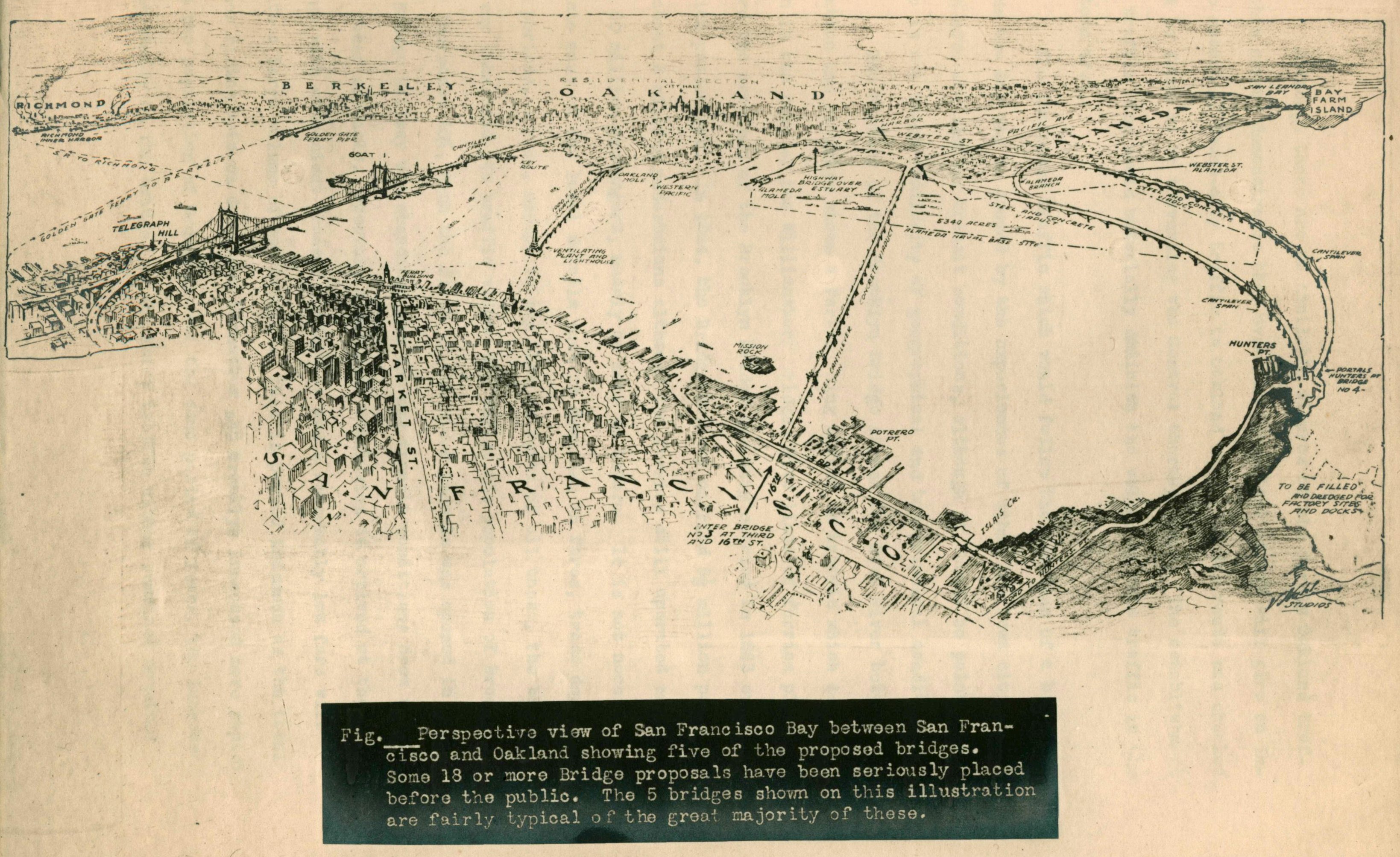
Perspective view of San Francisco Bay between San Francisco and Oakland showing five of the proposed bridges. The Traffic Ring Boulevard: A factor in solving the traffic problem in Oakland (1926). Source: Eric Fischer.
To sort through all 18 proposals, the Supervisors in February 1927 authorized San Francisco’s Department of Public Works to create a "Board of Engineers" tasked with studying the options and recommending a ranked list of the three best.
In April 1927, this Board of Engineers produced the following map illustrating its recommendations. Note the terminology: “Transbay Bridge.”
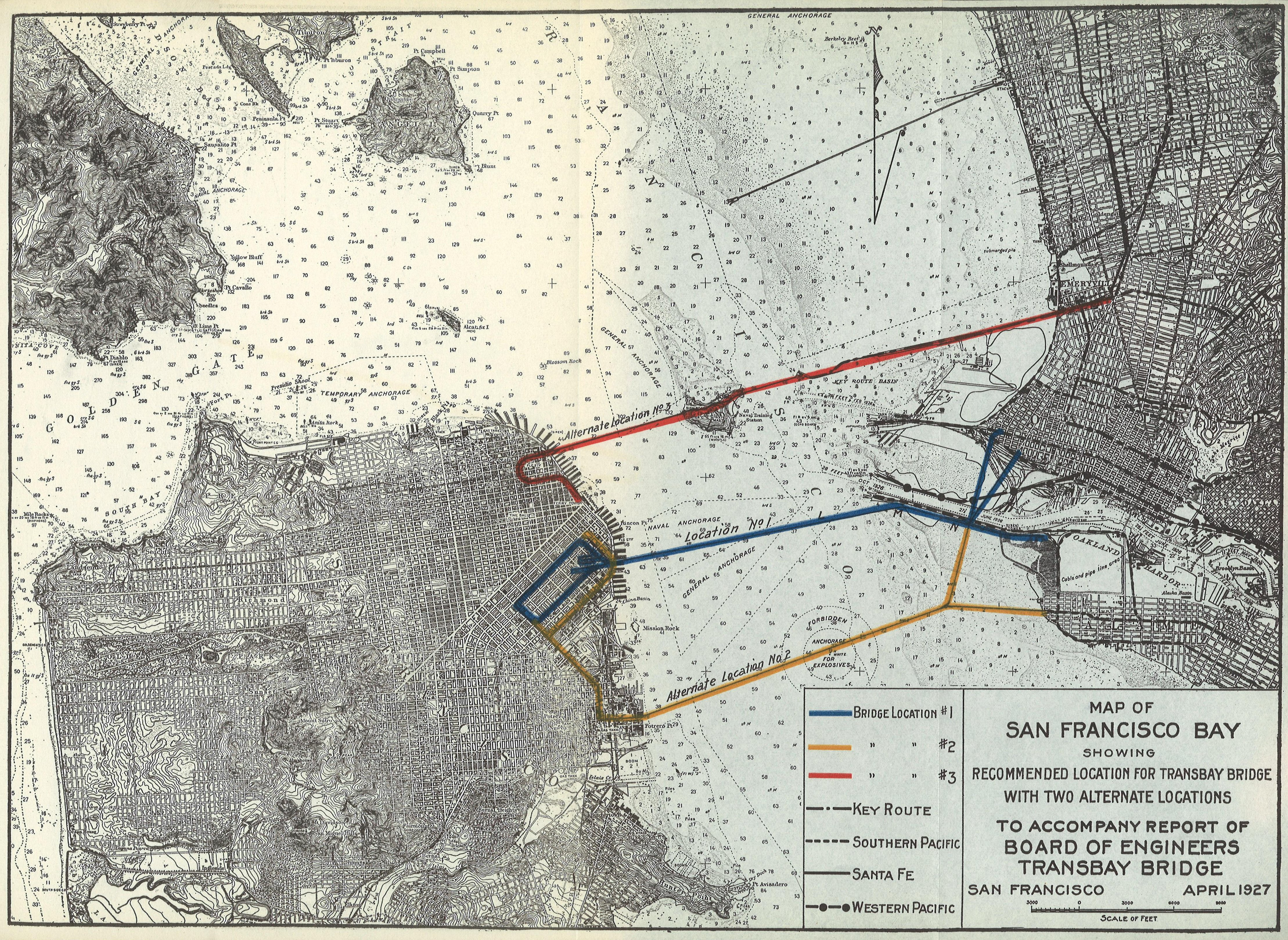
Map of San Francisco Bay Showing Recommended Location for Transbay Bridge with Two Alternate Locations, April 1927. Report of the Bureau of Engineering of the Department of Public Works, City and County of San Francisco (Fiscal Year Ending June 30, 1927), insert between pages 18 and 19. Map source: Internet Archive. Image source: Found SF.
In order of preference, Location No. 3, on “top,” is what Emperor Norton decreed. Interestingly, what was built 1933–36 basically was Location No. 3 revised to incorporate the San Francisco touchdown of Location No. 1.
That configuration was formally introduced and recommended as the best option by a presidential commission that took up the issue in 1929 and 1930. More about this shortly.
Suffice to say, at this point, that any transbay bridge would need Congressional approval, since San Francisco Bay was regarded as key to the national security and commercial shipping interests of the United States.
So it was that, in March 1928, the U.S. Senate Committee on Commerce held a three-day hearing on S. 1762, “a bill granting consent to the city and county of San Francisco, the State of California, its successors and assigns, to construct, maintain, and operate a bridge across the Bay of San Francisco from Rincon Hill to a point near the south mole of San Antonio Estuary, in the county of Alameda, in said state.”
This was Location No. 1 in the 1927 report of the Board of Engineers of the San Francisco Department of Public Works (DPW) — the “middle route” in the map immediately above.
The title of the published proceedings of the 1928 hearing was “Bridge Across the Bay of San Francisco.”
In 1928, the primary stipulation of various shipping concerns was that any bridge have sufficient clearance.
However, the Secretary of War, Dwight F. Davis, submitted a January 1928 letter repeating the Department’s adamant opposition — first stated in December 1921 and reaffirmed in October 1927 — to any bridge north of Hunters Point. This would have ruled all three route options shortlisted in the report of the San Francisco DPW.
The War Department’s position seems to have been that it might want to build a military anchorage in the Bay at some point — and it didn’t want to have its options limited.
Backers of the bridge project — including members of the Commerce Committee — thought that it was an unreasonable overreach of the War Department to try to draw this kind of line in the sand during peacetime — especially when the Department had no actual plans to build any anchorage in San Francisco Bay.
:: :: ::
In summer 1929, the California legislature moved forward with creating the California Toll Bridge Authority, which would have the power to construct and acquire toll bridges.
President Herbert Hoover — who had assumed office in March — had become interested in the project. And, in October 1929, Hoover and California Governor C.C. Young established what became known as the Hoover-Young San Francisco Bay Bridge Commission.
In its report of August 1930, the Hoover-Young Commission studied five options, shown in the following map.
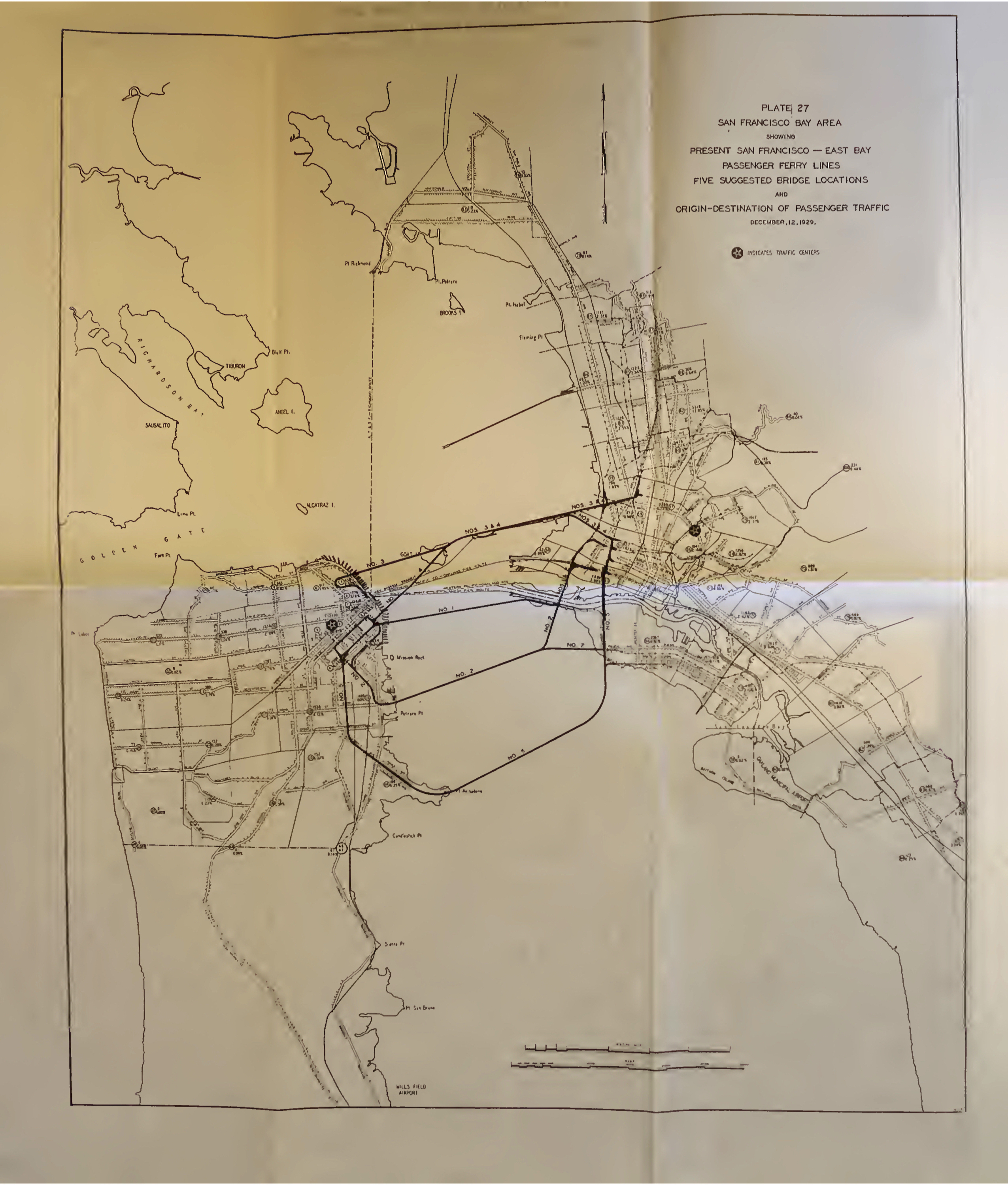
San Francisco Bay Area Showing…Five Suggested Bridge Locations (map), 12 December 1929. Report of the Hoover-Young San Francisco Bay Bridge Commission, August 1930, Plate No. 27, p. 207. Source: Internet Archive.
Location Nos. 1, 2 and 3 were the same as in the San Francisco DPW study of 1927. Remember that Location No. 3 was the “Emperor Norton” route from Oakland to Telegraph Hill via Goat Island (Yerba Buena Island).
To this was added two more options. Location No. 4 was the same as Location No. 3 from Oakland to Goat Island. But, west of Goat Island, the route pivoted south to the same Rincon Hill landing as in Location No. 1.
Location No. 5 had its San Francisco landing at Hunters Point — no doubt, an effort to recognize the Department of War, which had suggested that Hunters Point was the northernmost landing that it would approve.
The Commission recommended Location No. 4, noting in its report that
(a) No other location offers a more direct connection between traffic centers.
(b) Location No. 4 is the only location on which shale or rock foundations can be obtained for all heavy piers within practical depths.
(c) The cost of a double deck structure on Location No. 4 is $7,250,000 less than on Location No. 3 [Telegraph Hill landing] and $23,000,000 less than the cheapest structure on Location No. 1.
(d) Location No. 4 connects the most desirable traffic distribution centers in San Francisco and Oakland.
(e) Location No. 4 is superior to Location No. 3 in its effect on navigation and Location No. 1 shows no advantage in this respect when naval interests are considered.
(f) On Location No. 4, the present rate of ferry tolls can be materially reduced and the bridge paid for in less than twenty years.
Five months later, on 20 February 1931, the U.S. Congress passed “an Act Granting the consent of Congress to the State of California to construct, maintain, and operate a bridge across the Bay of San Francisco from the Rincon Hill district in San Francisco by way of Goat Island to San Francisco.”
Holding out until the last moment, the Departments of War, Navy and Commerce issued joint permits in January and May 1932 both approving the general location and plan for the bridge and providing specific right-of-way across Yerba Buena Island, which was a U.S. military reservation.
It seems likely that President Hoover had to pull rank, twist arms and possibly even bang some heads to get the War Department to “stand down” from its previous longstanding objection to a transbay bridge north of Hunters Point.
:: :: ::
In August 1930, the Hoover-Young Commission called it the “San Francisco Bay Bridge.”
But, by August 1932, the California Department of Public Works issued a report to the California Toll Bridge Authority calling it the “San Francisco-Oakland Bay Bridge.”
The California DPW’s 1932 report included this map showing what was to come.
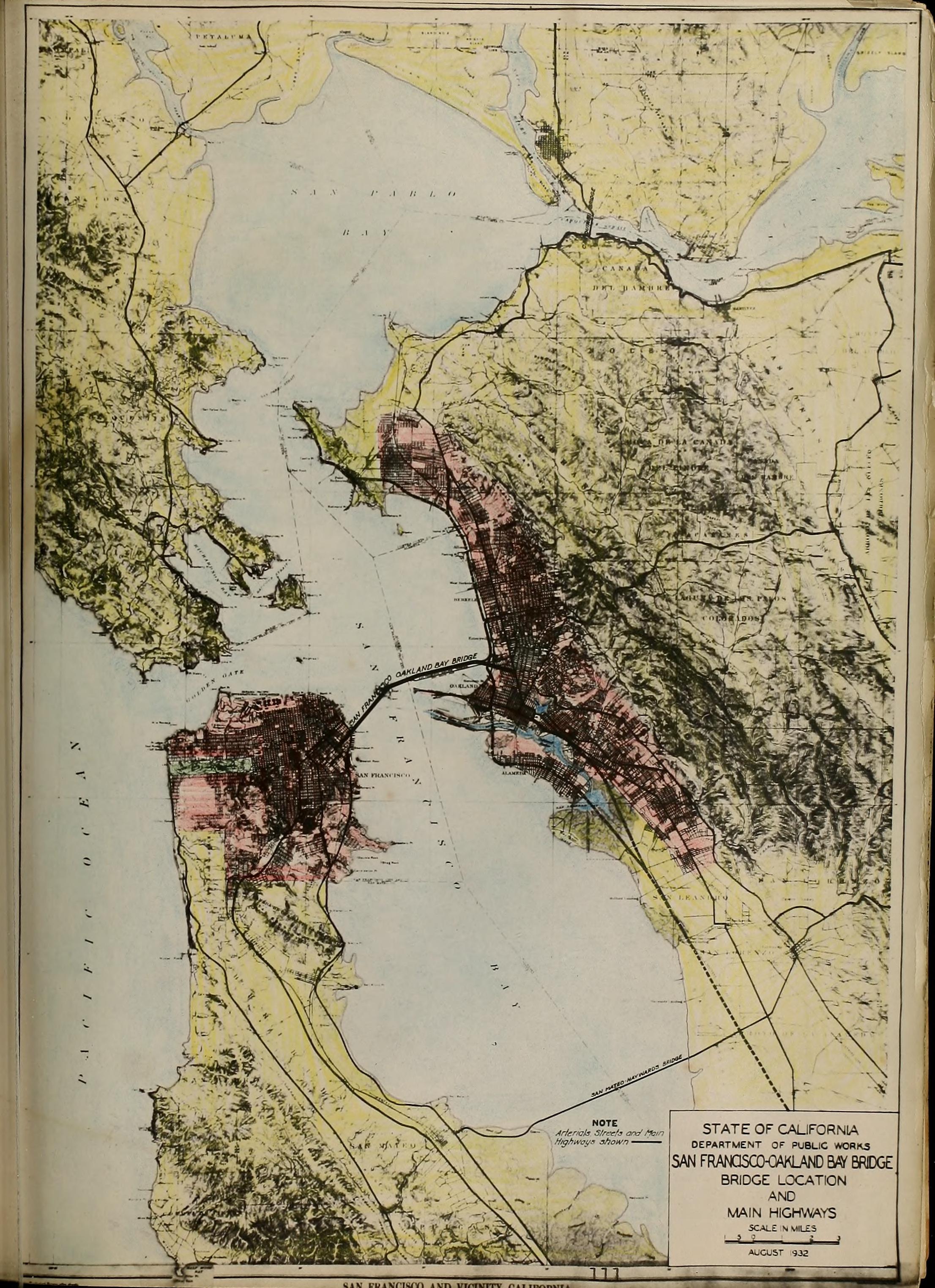
San Francisco-Oakland Bay Bridge, Bridge Location (map). San Francisco-Oakland Bay Bridge: Report to the California Toll Bridge Authority, State of California Department of Public Works, August 1932, p. 111. Source: Internet Archive.
Given that the "Goat Island" strategy prevailed, one would have to say that, all in all, the Emperor "won."
* In December 2019, The Emperor's Bridge Campaign adopted a new name: The Emperor Norton Trust.
:: :: ::
For an archive of all the Trust’s blog posts and a complete listing of search tags, please click here.
Search our blog...