New Transbay Transit Center Is in Norton's Old Neighborhood
There's been a lot of fanfare the last few days about the long-awaited grand opening of the new Transbay Transit Center, in San Francisco's SOMA neighborhood.
Formally called the Salesforce Transit Center — after the company that bought the private naming rights to this public transit facility, and whose surpassingly tall new Salesforce Tower stands next door — the new Center replaces, and is on the former site of, the old Transbay Terminal, which opened in 1939 and was demolished in 2010.
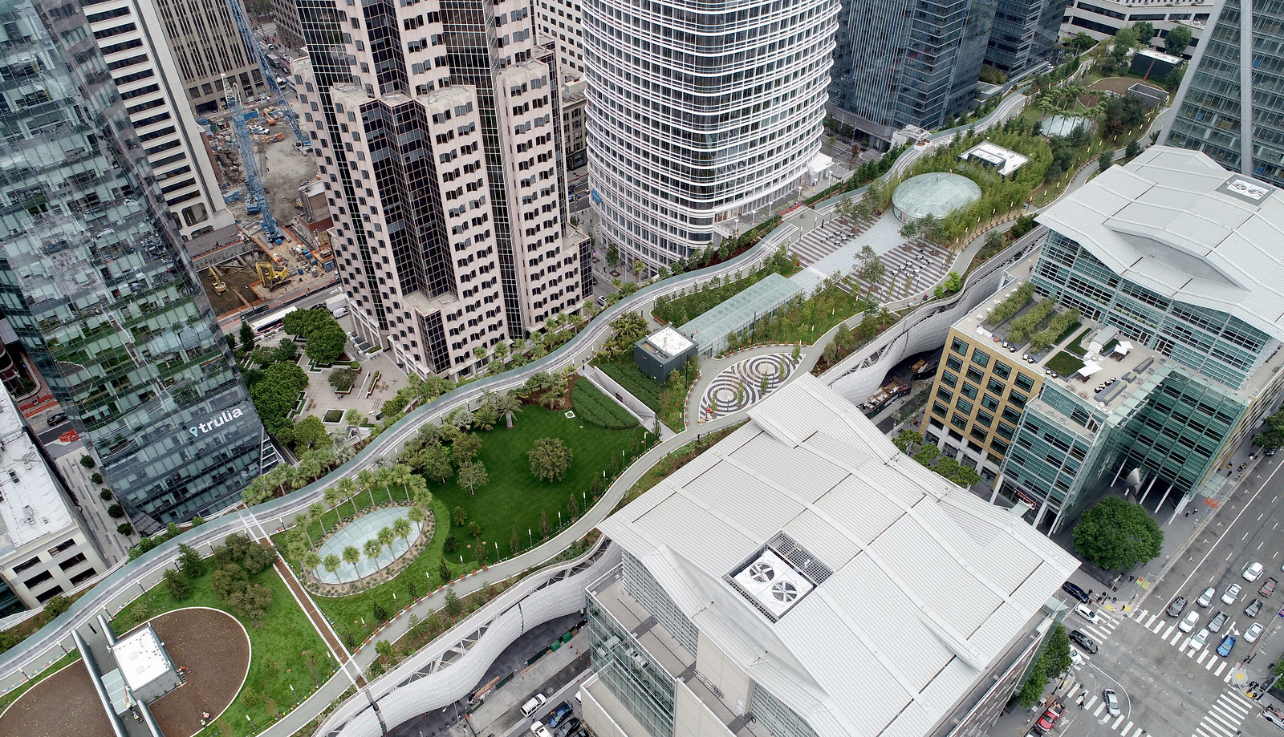
Transbay Transit Center and Park. Drone view on 8 August 2018. © 2018 Jane Tyska / Bay Area News Group.
Exceptionally few people — including self-avowed students of Emperor Norton history — are aware that the Transbay site is just steps away from the former sites of some of the most significant properties owned and used between 1850 and 1855 by the "pre-imperial" businessman known as Joshua Abraham Norton.
No doubt, this "blind spot" is partly due to the fact that, some 32 years ago, the Transbay site was imbued with a different Norton-related significance.
:: :: ::
A quick historical recap....
The Ancient and Honorable Order of E Clampus Vitus is a fraternal organization whose members — known as the Clampers — revere the Emperor Norton as a patron saint.
Shortly after the opening of the San Francisco-Oakland Bay Bridge in November 1936, the Clampers commissioned a plaque to honor the Emperor for setting out the original vision for the bridge in 1872. In fact, the date the Clampers put on the plaque was 1869, which is mistaken — but, their hearts were in the right place.
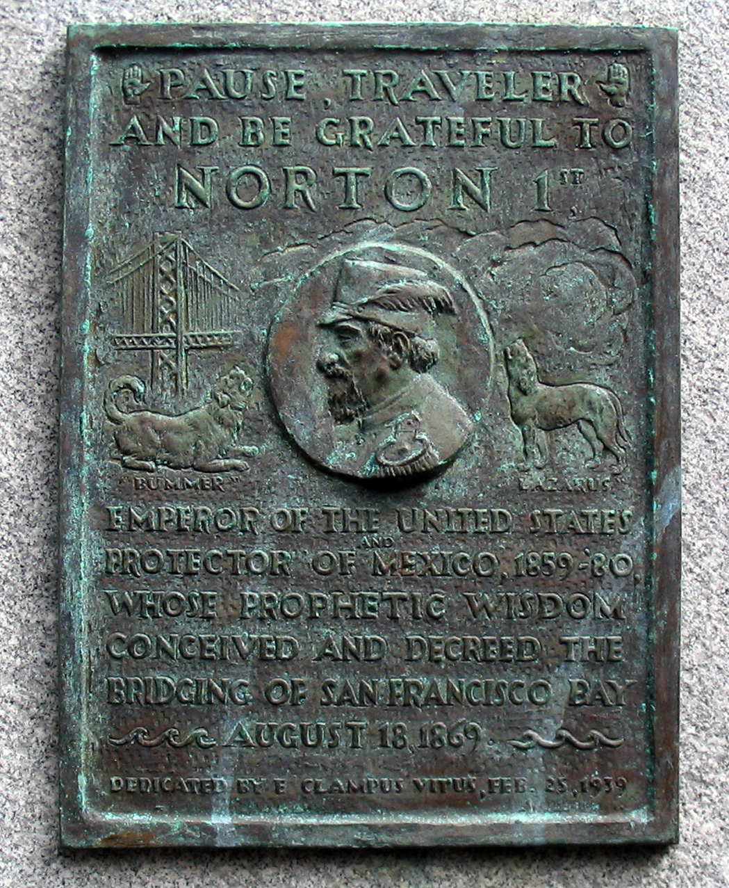
Plaque, commissioned by E Clampus Vitus, honoring Emperor Norton for setting out the vision for the San Francisco-Oakland Bay Bridge. Photograph: John Nagle. Source: Wikimedia Commons.
At any rate, the plaque was dedicated in 1939, with the intention and hope that it be mounted on the bridge. The state bridge authorities balked; U.S. involvement in the war shifted priorities; and the plaque was placed in storage until 1955, when it was installed at the Cliff House.
There the plaque remained for thirty years — until 1986, the 50th anniversary of what those in the know call the Emperor Norton Bridge.
Seizing on this commemorative opportunity, the Clampers secured permission to move the plaque to the Transbay Terminal, reasoning that the Terminal served the busses that traveled across the Emperor Norton. The connection was a little tenuous, to be sure — but, it was something. Certainly, it got the plaque closer to the bridge than the Cliff House was. (For more on this story, see here.)
The plaque was removed for safekeeping when the old Terminal was demolished in 2010. Some hope that the plaque will be returned for display in the new transit center. This would be fitting.
But, perhaps a transit center installation of the plaque should be regarded as a temporary solution.
The new Eastern crossing of the Emperor Norton features a pedestrian / bicycle path from Oakland to Yerba Buena Island — and there are plans to add a companion path to the Western crossing, from the Island to San Francisco. Given the actual language of the plaque — "Pause, Traveler, And Be Grateful to NORTON 1st...Whose Prophetic Wisdom...Decreed the Bridging of San Francisco Bay" — it seems to me (and I am not the only one to suggest this) that the ideal location for the plaque would be at the Yerba Buena Island midpoint of the pedestrian / bicycle path across the Bay, once the Western path is complete and crossing the entire Bay by foot or bike finally is possible.
Clampers, consider this a seed planted.
:: :: ::
The point is that most people who make any kind of connection between the Transbay site and Norton do so based on a plaque...
that was created 79 years ago, in 1939;
that was not originally intended to be placed at the Transbay site;
that didn't get attached to the Transbay site until 1986 — forty-seven years after its dedication; and
that — beautiful as it is, both in fabrication and in sentiment — doesn't forge any connection between the site and Norton.
Meanwhile, two sites with deep, documented connections to Joshua Norton are barely a stone's throw away.
The new transit center occupies a long, narrow site. The length of the center is bordered by (roughly) Second Street on the west and Beale Street on the east. The narrow width of it — situated between the major arteries of Mission Street to the north and Howard Street to the south — is bordered by the mid-block "alley streets" of Minna on the north and Natoma on the south.
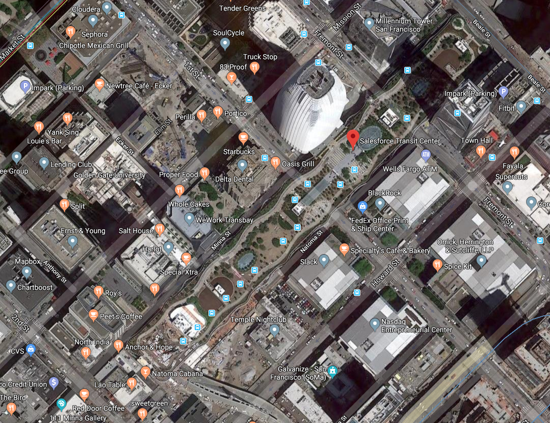
Transbay (Salesforce) Transit Center. Screen cap of Google Maps satellite view.
Think, for a moment, about the one-block section of the transit center between First (west) and Fremont (east) — again, with Natoma on the south.
Continuing south, the next street over from Natoma — the tiniest of blocks — is Howard.
Our focus now is on two intersections: (1) First and Howard and (2) Fremont and Howard.
Probably in 1850, Joshua Norton, the future Emperor — newly arrived to San Francisco in late 1849 — bought two "water lots" near what later became First and Howard.
At around the same time, Norton bought an abandoned ship, the Genessee. He cut off the Genessee's masts, roofed it over and converted it into a storeship — a warehouse. This storeship was anchored near what later became Fremont and Howard.
There was no need for Norton to develop the water lots — their value immediately increased when the Pacific Mail Steam-Ship Company built its new passenger terminal and warehouse next door. Arriving Pacific Mail vessels could berth in Norton's lots and unload their cargos — including onto Norton's nearby storeship, the Genessee.
Much is made of the fact that Joshua Norton acquired three of the four corners of Sansome and Jackson Streets. And it's true that what Norton built and developed on these three corners — an office building; a cigar factory; and a rice mill — became the administrative and production hub of his enterprise.
But, the trading hub — where Norton physically downloaded, uploaded and offloaded the commodities on which his businesses depended — this was taking place near Howard, between First and Fremont.
Just next door to where the new Transbay Transit Center opened this past weekend.
In the map below, the red pin marks the transit center, whose narrow contour is lined out by the Muni bus icons. The blue pins mark the former sites of Norton's water lots at First and Howard and his storeship, the Genessee, at Fremont and Howard.
No doubt, every day from about early 1850 to early 1855, Joshua Norton made his way south from his offices in today's Financial District, across the area now occupied by the western half of the transit center, to inspect his operations and make sure that his workers were keeping things on schedule.
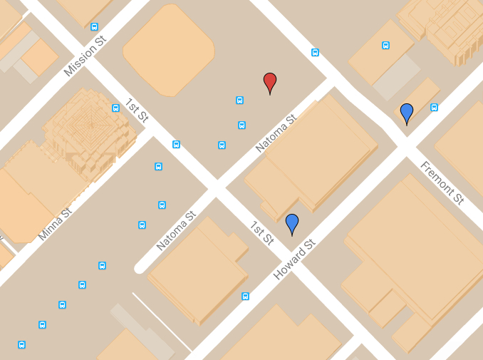
The former sites of Joshua Norton's receiving and warehousing operation (blue pins) relative to the new Transbay Transit Center (red pin). For a full interactive map of 47 sites that are historically associated with Emperor Norton and 14 sites of Emperor-inspired public art, see our dynamically updated Emperor Norton Map of the World.
Here's a thought...
The Transbay Transit Center is a new magnet site in the midst of the oldest of Old San Francisco.
How about using the Center as an opportunity to show everybody who passes through this new crossroads what historically significant sites are close by?
How about a prominent feature in the Center that would direct visitors to sites that are within walking distance?
How about putting a plaque or some other historical marker on all of these sites?
Let's connect passengers and other users to the Center's historical surroundings.
I have suggestions for two plaques!
:: :: ::
For an archive of all the Trust’s blog posts and a complete listing of search tags, please click here.
Search our blog...